Synopsis:
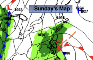
A storm will ride up and well off the coast later today and Sunday tonight. The storm will be far enough away to just give the area a few showers today and early tonight.
It’ll be a bright, mild start to the week with highs almost ten degrees above the average high of the lower 50s.
Tuesday and Wednesday will be chilly courtesy of Canadian high pressure. Wall to wall sunshine is expected.
All models have a developing area of low pressure over the Southeastern states on Thanksgiving. This storm will move North and strengthen. Rain is likely to develop by midday and continue through the evening. It will become windy.
Stay tuned.
Keep it here for a no nonsense, no hype forecast…
Sunday:
Cloudy. Areas of fog. Scattered showers this afternoon. Highs around 60º. Northeast winds at 5-10mph.
Tonight:
Cloudy. A few showers. Lows in the mid 50s in the City, the 40s inland. Northeast to Northwest winds at 8-12mph.
Monday:
Mostly sunny. Mild. Highs in the lower 60s.
Tuesday:
Mostly sunny, breezy and much cooler. Highs in the mid to upper 40s.
Wednesday:
Mostly sunny. Chilly. Highs in the mid 40s.
Thanksgiving:
Cloudy with rain developing by midday. Becoming windy. Highs around 50º.