Synopsis:
Low pressure will continue to move East off the NJ coast today. The rain will continue on through this morning along with gusty winds. The rain will taper off during the afternoon. There maybe some wet snow mixed in at times inland. Readings today will be unseasonably chilly as colder air works in from the North.
The weekend will be chilly with gusty winds under a mix of clouds and sun. Highs will be about ten degrees below the average high of the mid to upper 50s. Gather up that firewood.
The chill will remain on Monday as high pressure moves over the region.
More seasonal temperatures are expected by Tuesday under bright skies.
Stay tuned.
Keep it here for a no nonsense, no hype forecast…
Friday:
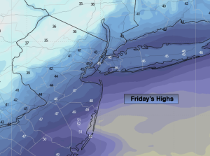
Morning rain will taper off during the afternoon. There maybe some wet snow mixed in at times inland. Breezy. Chilly. Highs in the mid 40s. North winds at 15-25mph with gusts to 30mph.
Tonight:
Early spot shower this evening, otherwise, partly cloudy. Cold. Lows in the mid 30s in urban areas, around 30º inland. North winds 10-20mph.
Saturday:
Partly sunny, windy and cold. Highs in the mid to upper 40s. Wind chills in the upper 30s.
Sunday:
Partly sunny. Breezy. Highs around 50º.
Monday:
Sunny. Highs in the lower 50s.
Tuesday:
Sunny. Seasonal. Highs in the mid 50s.