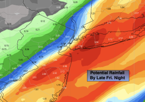
Synopsis:
A period of rain is likely Friday, especially from the I-95 corridor and to the coast as the front stalls on or just off the coast. Some heavier rainfall is possible especially at the coast. It all depends on where the heaviest axis of rain sets up. The potential is there for a couple of inches of rain. The potential rain rainfall map is above.
As the low and front moves off the Northeast coast this weekend cooler temperatures will be experienced. Actually, more seasonal readings. A mix of sun and clouds is expected Saturday with readings a few degrees above average. Seasonal high are in the upper 50s to around 60º. A few spotty showers are possible. Sunday will be breezy with near average temperatures under mainly sunny skies.
Monday and Tuesday will feature abundant sunshine and typical readings for this time of the year as high pressure takes control.
Stay tuned.
Keep it here for a no nonsense, no hype forecast…
Friday:
Periods of rain likely, especially toward the coast. Rain maybe heavy at times along and South and East of the urban corridor. Highs in the upper 60s. Winds light and variable.
Tonight:
Any rain this evening along the coast will end early. Becoming partly cloudy. Lows in the mid 50s in urban areas, the 40s inland. Northwest winds at 5mph.
Saturday:
Sun and clouds. Spotty shower possible. Highs in the lower 60s.
Sunday:
Partly sunny. Breezy. Seasonal. Highs in the upper 50s to around 60º.
Monday:
Sunny. Highs in the upper 50s to around 60º.
Tuesday:
Mostly sunny. Milder. Highs in the mid 60s.