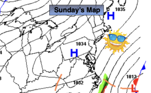
Synopsis:
After a morning with readings in the 30s in most areas, temperatures will only recover to the 50s. Strong high will dominate over the Northeast. Wall to wall sunshine is expected despite the chill.
It’s an atmospheric traffic jam for this upcoming week. High pressure will be anchored over the Northeast this entire week. An offshore storm will remain over the Western Atlantic. This system will kick up winds, seas and surf at the beaches. Some beach erosion is possible. We are not expecting any rain from this storm. Abundant sunshine and seasonably cool conditions is excepted through Friday.
Stay tuned.
Keep it here for a no nonsense, no hype forecast…
Sunday:
Sunny and cool. Highs in the mid to upper 50s. North winds at 5mph.
Tonight:
Clear and cold. Lows in the mid 40s in urban areas, the upper 20s and 30s inland. Light North to Northeast winds.
Monday:
Sunny. Highs in the lower 60s.
Tuesday:
Sunny. Seasonal. Highs in the mid 60s.
Wednesday:
Sunny. Highs in the lower 60s.
Thursday:
Sunny. Highs in the lower 60s.