Synopsis:
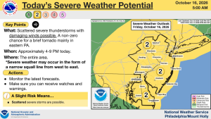
A cool front will approach toward evening with showers and storms. Some of the storms may become severe. Keep an eye to the sky for threatening weather after 4pm. Showers and storms will end later this evening, skies will remain mostly cloudy.
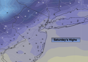
This cool front will be significant as it’s bringing down the coldest air of the season with it. Saturday’s highs will remain in the 50s under partly sunny skies. Strong winds gusts from the North up to 30mph is expected. Making the 50s feel like the 40s during the afternoon.
Areas to the North and West will most likely experience a frost and or freeze Saturday night.
It’ll be more tranquil on Sunday with strong high pressure over the area. Sunny, cool conditions are expected.
Monday and Tuesday will feature a mix of sun and clouds. High pressure will be to the North and East. Offshore low pressure will remain nearly stationary but not close enough for any rain. This system will create rough seas and large breakers at the beach.
Stay tuned.
Keep it here for a no nonsense, no hype forecast…
Tonight:
An evening storm, otherwise mostly cloudy, breezy and much cooler. Lows in the 40s to around 50º in the City. Northwest winds 10-20mph with gusts to 30mph.
Saturday:
Clouds to sun, windy and much cooler. Highs only in the lower to mid 50s. North 10-20mph with gusts to 30mph.
Sunday:
Sunny and cool. Highs in the upper 50s.
Monday:
Partly sunny. Highs in the lower 60s.
Tuesday:
Partly sunny. Seasonal. Highs in the mid 60s.
Wednesday:
Mostly sunny. Highs in the lower 60s.