Synopsis:
Tranquil conditions are expected for several days. High pressure will basically sit on or off the East coast through Saturday.
After a frosty morning over parts of the interior today it’ll be a midweek delight this afternoon with abundant sunshine and cool readings.
As the high moves off the coast milder air will work in for Thursday. It’ll be bright with readings above the average high of the upper 60s.
Friday and Saturday will feature near average temperatures and plenty of sunshine.
Sun will give way to clouds on Sunday as moisture moves up from the South. Showers are possible later in the day, but this remains to be seen as the remnants of a tropical system moves up the spine of the Appalachians.
Stay tuned.
Keep it here for a no nonsense, no hype forecast…
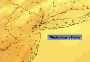
Wednesday:
Mostly sunny. Highs in the mid 60s. Southwest winds at 8-12mph.
Tonight:
Clear and cool. Lows in the upper 50s in the City, the 40s inland. Light Southwest winds.
Thursday:
Sunny. Mild. Highs in the mid 70s.
Friday:
Sunny. Pleasant. Highs around 70º.
Saturday:
Sunny. Pleasant. Highs around 70º.
Sunday:
Sun to clouds. Chance of late day showers. Highs around 70º.