Synopsis:
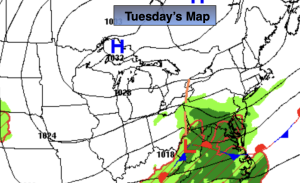
Scattered showers are likely for areas to the South of the City on Tuesday morning as a ripple of low-pressure heads east and off the Mid-Atlantic coast. There’ll be sunshine, especially over Northern areas during the afternoon.
Gusty winds, especially along the coast, are likely from Tuesday through Saturday as strong high pressure remains to the North and an offshore storm meanders for a few days. Rough seas, beach erosion and coastal flooding is possible. If the storm retrogrades and heads more toward the region on Friday night and Saturday a period of rain and higher winds are possible. This is a low potential right now, but has to be watched as new computer guidance comes in.
Readings will only be in the 60s under a mix of sun and clouds mid to late week.
Autumn arrives today at 8:05PM EDT.
Keep it here for a no nonsense, no hype forecast…
Tuesday:
Mostly cloudy. Scattered showers mainly South of the City during the morning. Breezy and cool. Highs in the mid 60s. Northeast winds at 10-20mph with gusts to 25mph.
Tonight:
Partly cloudy. Cool. Lows in the mid 50s in the City, the 40s inland. Northeast winds at 10-20mph with gusts to 25mph.
Wednesday:
Partly sunny. Breezy and cool. Highs in the mid to upper 60s.
Thursday:
Partly sunny. Breezy and cool. Highs in the mid to upper 60s.
Friday:
Mostly cloudy. Breezy. Highs in the mid to upper 60s.
Saturday:
Mostly cloudy. Low potential for rain and gusty winds. Highs in the lower 60s.