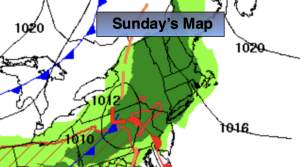
Synopsis:
The chances of showers increase on Tuesday as a ripple of low-pressure heads east and off the Mid-Atlantic coast. Gusty winds, especially along the coast, are likely from Tuesday through Friday as strong high pressure remains to the North and an offshore storm meanders for a few days. Readings will only be in the 60s, right on target for the beginning of autumn, which starts Tuesday.
Keep it here for a no nonsense, no hype forecast…
Sunday:
Periods of rain. Local downpours. Highs in the upper 60s. Southeast winds at 5-10mph.
Tonight:
Areas of showers early. Partly cloudy late. Lows around 60º in the City, the 50s inland. West to North winds at 10-15mph.
Monday:
Sun and clouds. Highs in the upper 60s.
Tuesday:
Mostly cloudy. Breezy and cool. Scattered showers. Highs in the lower 60s.
Wednesday:
Mostly cloudy. Breezy and cool. Highs in the mid 60s.
Thursday:
Mostly cloudy. Breezy and cool. Highs in the mid 60s.