Synopsis:
Very warm conditions are expected through Thursday. It won’t be record heat but it will still be uncomfortable. Not the worst for August. High pressure over the Southeast will slowly dissipate. A spot storm is possible late today. A few showers are possible Thursday morning. A cool front will move into the region later Thursday and Friday. Friday will feature pleasant temperatures and low humidity.
Stay tuned.
Keep it here for a no nonsense, no hype forecast….
Tuesday:
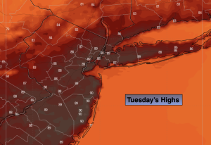
Partly sunny. Hot. Isolated late day storm. Highs in the upper 80s. West winds at 5-10mph.
Tonight:
Spotty early storm, otherwise, partly cloudy. Lows in the lower 70s in the City, the 60s inland. Light Northwest wind.
Wednesday:
Mostly sunny. Highs the upper 80s.
Thursday:
Chance of a morning shower, otherwise, partly sunny. Highs in the mid 80s.
Friday:
Mostly sunny. Not as warm and less humid. Highs in the lower to mid 80s.
Saturday:
Sunny. Low humidity. Highs in the lower 80s.