Synopsis:
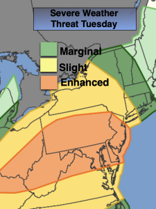
A warm front will move toward the area on Tuesday. Cloudy skies are expected. Showers are possible in the morning with the chance of afternoon storms. Some of the storms may become strong to severe. Much of NJ is in an enhanced risk for severe storms. Keep an eye to the sky for threatening weather between 2pm-8pm.
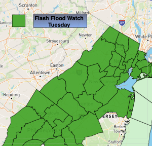
Torrential rain is possible with any storm. A Flood Watch has been posted for much of NJ and NYC. Never drive through flood roadways. Turn around-don’t drown.
Scattered showers and a thunderstorm is possible Wednesday as a cool front will be slow to move offshore. The sun will most likely make an appearance.
Thursday and Friday will feature sunshine and comfortable temperatures as high pressure dominates the Northeast.
The weekend looks nice at this time with weak high pressure moving off the coast. Mostly sunny skies and comfortable temperatures are expected.
Stay tuned.
Keep it here for a no nonsense, no hype forecast….
Tuesday:
Mostly cloudy. Scattered morning showers. Chance of afternoon storms. Areas of torrential rain. Highs in the lower 80s.
Tonight:
Scattered showers and storms early, otherwise becoming partly cloudy. Lows around 70º in the City, the 60s inland. South winds at 5-10mph.
Wednesday:
Partly sunny. Spotty showers. A thunderstorm is possible. Highs in the mid 80s.
Thursday:
Sunny. Highs in the lower 80s.
Friday:
Sunny. Highs in the lower to mid 80s.
Saturday:
Mostly sunny. Highs in the lower 80s.