Synopsis:
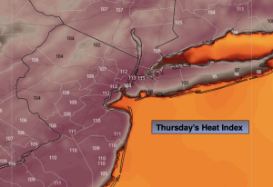
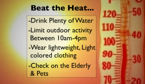
A heat wave will continue to grip the region as a Bermuda high remains in place. Temperatures today and Friday will top the century mark in many areas. Many record will be broken today. The heat index will range between 105º-115º. The heat will continue into the 4th of July weekend. This will be a prolonged heat wave. Please take into consideration the “Beat the Heat” tips above.
Isolated storms are possible Friday evening, Saturday and Sunday afternoon.
Stay tuned.
Keep it here for a no nonsense, no hype forecast…
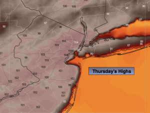
Thursday:
Hazy, hot and humid. Highs 99º-104º. Heat index 105º-115º. West to Southwest winds at 5-10mph.
Tonight:
Partly cloudy. Very warm. Lows around 80º-85º in the City, the 70s elsewhere. Southwest winds 5-10mph.
Friday:
Hazy, hot and humid. Spotty PM storm. Highs 99º-104º. Heat index near 100º-107º.
4th of July:
Hazy, hot and humid. Spotty PM storm. Highs 93º-98º. Heat index near 100º-105º.
Sunday:
Sun and clouds. Still hot, but not as oppressive. Scattered afternoon storms. Highs around 90º.
Monday:
Relief arrives. Sun and clouds. Scattered afternoon storms. Highs in the mid 80s.