Synopsis:
Today will be a winner with plenty of sun, seasonally warm temperatures and low humidity. Weak high pressure along the East coast is responsible for our delightful conditions.
A disturbance will approach the area tonight and Friday morning. A few showers are possible. The sun will return later Friday morning and afternoon. Temperatures will be near the average highs of the mid 80s.
A front to our South with weak low pressure riding along it will result in a mainly cloudy Saturday. Showers are likely along with cooler readings.
The better half of the weekend will be Sunday. Sunny skies along with warm temperatures are anticipated.
Monday will be sunny and warm as high pressure builds into the areas.
Stay tuned.
Keep it here for a no nonsense, no hype forecast…
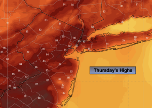
Thursday:
Partly sunny. Highs in the mid 80s. South winds at 8-12mph.
Tonight:
Mostly cloudy. A few shower possible. Lows in the mid to upper 60s throughout. South winds at 5mph.
Friday:
Scattered morning shower, otherwise a mix of sun and clouds. Highs in the mid 80s.
Saturday:
Mostly cloudy. Scattered showers. Highs in the mid 70s.
Sunday:
Sunny. Warm. Highs in the mid 80s.
Monday:
Sunny. Warm. Highs in the mid to upper 80s.