Synopsis:
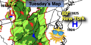
High pressure will move off our coast by late today. It’ll be a beauty with readings near the average highs of the upper 70s.
A more humid airmass will move into the region on Wednesday. More clouds are expected with a chance of a few showers or storms in the afternoon.
The heat will return Thursday and Friday with highs both days in the lower 90s as the heat pump high stays in control. A spot PM storm is possible Thursday.
Saturday will be very warm but dry under a mix of sun and clouds.
Stay tuned.
Keep it here for a no nonsense, no hype forecast…
Tuesday:
Sunny. Highs around 80º. Southwest winds at 10-20mph.
Tonight:
Partly cloudy. Lows in the mid 60s in the City, near 60º inland. Light Southwest wind.
Wednesday:
Mostly cloudy. Spotty PM Storm. Highs in the lower 80s.
Thursday:
Hazy, hot and humid. Spotty PM storm. Highs in the lower 90s.
Friday:
Partly sunny. Hot. Highs in the lower 90s.
Saturday:
Partly sunny. Highs in the upper 80s.