Synopsis:
Monday through Wednesday will feature abundant sunshine as high pressure moves from our area to off the Southeast coast. Temperatures will be near the average highs of the upper 70s on Monday and then become quite warm by midweek.
The heat will return Thursday and Friday with highs both days in the lower 90s as the heat pump high stays in control. A spot PM storm is possible on Friday.
Stay tuned.
Keep it here for a no nonsense, no hype forecast…
Tonight:
Mostly clear. Lows in the lower 60s in the City, the 50s inland. North to Northeast winds at 8-12mph.
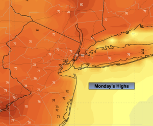
Monday:
Sunny. Seasonal. Highs in the upper 70s. East to South winds at 5-10mph.
Tuesday:
Sunny. Warmer. Highs in the mid 80s.
Wednesday:
Mostly sunny. Highs in the upper 80s.
Thursday:
Hazy, hot and humid. Highs in the lower to mid 90s.
Friday:
Partly sunny. Hot. Spotty PM storm. Highs in the lower 90s.