Synopsis:
High pressure over the Great Lakes will move to off the Southeast coast by Saturday. This will result in bright skies and moderating temperatures through the week. Temperatures will rise to above seasonal levels by Wednesday as a warm push works in with a Southwest wind. By Friday and Saturday it’ll become hot as the airmass continues to grow into a Summer-like pattern.
Sunday will feature relief with a cool front working through the region. Temperatures will drop and scattered showers are likely.
Stay tuned.
Keep it here for a no nonsense, no hype forecast…
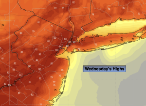
Wednesday:
Mostly sunny. Highs in the lower 80s. North to South winds at 5-10mph.
Tonight:
Clear. Lows in the mid 60s in the City, the 50s inland. Light South wind.
Thursday:
Mostly sunny. Warmer. Highs in the mid 80s.
Friday:
Mostly sunny. Hot. Highs in the lower 90s.
Saturday:
Mostly sunny. Hot. Highs in the mid 90s.
Sunday:
Mostly cloudy. Cooler. Scattered showers. Highs in the lower 80s.