Synopsis:
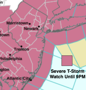
A Severe Thunderstorm Watch is in effect for the area until 9pm. Any thunderstorms have the capability of producing winds in excess of 58mph, small hail, vivid lightning and downpours. Keep an eye to the sky for threatening weather. This is all due to a strong cold front that will move through late this evening.
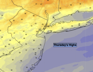
A major temperature swing is on the way. We’ll go from the 90s of today to the 60s Thursday. Talk about a drop and relief!
The front will be slow to move offshore Thursday. Showers will linger for the morning and end around midday. Skies will remain mostly cloudy. More sun is likely to the North.
High pressure over Southeast Canada will keep us dry on Friday with a mix of sun and clouds. Readings will remain below the average highs of the lower to mid 7os.
Memorial Day Weekend still looks unsettled. Weak low pressure will remain to our South. This combined with strong high pressure over the Canadian maritimes will result in a raw flow off the ocean into Sunday. Periods of rain is likely Saturday. On Sunday the shower threat remains for the morning. The afternoon should be drier. At this time Memorial Day still looks like the best of the bunch with a mix of sun and clouds. A spot shower can’t be ruled out, but I wouldn’t cancel any outdoor plans. Highs will be near average.
Stay tuned.
Keep it here for a no nonsense, no hype forecast…
Tonight:
Scattered showers and storms this evening. Spotty showers after midnight. Much cooler. Lows in the 50s throughout. Winds becoming North at 8-12mph.
Thursday:
Mostly cloudy. Much cooler than recent days. Showers likely from the City and South through midday. Highs only in the lower 60s. Northeast winds at 8-12mph.
Friday:
Partly sunny Highs in the upper 60s.
Saturday:
Periods of rain. Chilly. Highs only in the upper 50s.
Sunday:
A bit of morning light rain, otherwise remaining mostly cloudy for the afternoon. Highs in the mid 60s.
Memorial Day:
Sun and clouds. Spot shower. Highs in the mid 70s.