Synopsis:
A cool front will approach today. Any early morning sun will give way to clouds. Scattered showers will develop during the early evening. Showers are in the forecast for tonight as the low and front move overhead.
Early morning showers Thursday should give way to some afternoon sun as the system moves offshore. Temperatures will be below average.
May’s debut on Friday will be pleasant under a mix of sun and clouds. Cool temperatures are expected this weekend as a chilly airmass remains over the Northeast. A mix of sun and clouds is expected.
Stay tuned.
Keep it here for a no nonsense, no hype forecast…
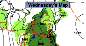
Wednesday:
Sun to clouds. Showers likely by evening. Highs in the lower 60s. Southeast winds at 5-10mph.
Tonight:
Showers. Lows around 50º in the City, the 40s inland. Southeast to Northeast winds less than 5-10mph.
Thursday:
Early morning showers to afternoon sun. Highs around 60º.
Friday:
Partly sunny. Highs around 60º.
Saturday:
Sun and clouds. Highs in the upper 50s.
Sunday:
Partly sunny. Highs around 60º.