Synopsis:
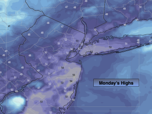
April will continue to give us the cold shoulder the next couple of days as Canadian high pressure moves in. Highs today and Tuesday will be ten degrees below the average high of the lower 60s. A mix of sun and clouds is expected.
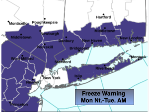
A Freeze Warning is in effect for most of the tri-state area excluding the immediate NYC vicinity for tonight. Readings will drop into the 20s in most areas. This will be a hard freeze please bring in any potted plants or cover vegetation that has been planted. They will be wilted by morning.
Upper level energy will swing Tuesday night and Wednesday with more clouds and spotty showers. Temperatures Wednesday will be closer to average.
Milder conditions are expected Thursday and Friday as high pressure dominates. Partly sunny skies are expected.
Stay tuned.
Keep it here for a no nonsense, no hype forecast…
Monday:
Mostly sunny. Chilly. Highs in the lower 50s. Northwest winds 10-15mph.
Tonight:
Clear and cold. Lows in the mid 30s in the City, the 20s inland. Northwest winds diminishing to 5 mph.
Tuesday:
Mostly sunny. Cool. Highs in the lower to mid 50s.
Wednesday:
Mostly cloudy. Spot Shower. Highs around 60º.
Thursday:
Partly sunny. Milder. Highs in the upper 60s.
Friday:
Partly sunny. Highs in the mid 60s.