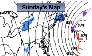
Synopsis:
An intense Western Atlantic storm on Sunday will continue to move up and well off the coast. The Northwestern shield of snow will stay offshore. It will be windy and cold under a mix of sun and clouds. Winds at the coast may gust to 40mph. Wind chills will be in the teens during the afternoon.
Early next week will finally offer some relief from the Arctic airmass. The core of the cold dome will move East allowing temperatures to rise to near freezing. A mix of sun and clouds are expected as a ridge of high pressure dominates. A few flurries or snow showers are possible Tuesday night into early Wednesday morning. This will not be a big deal. The big deal right now is our stretch of below freezing temperatures which is at 8 consecutive days through today.
Stay tuned.
Keep it here for a no nonsense, no hype forecast….
Sunday:
Partly sunny and windy. Highs in the mid to upper 20s. North to Northwest winds at 15-30mph with gusts to 40mph at the coast.
Tonight:
Mostly clear. Lows in the mid to upper teens along the coast, the single digits inland. Decreasing Northwest wind to 8-12mph.
Monday:
Mostly sunny. Highs in the lower 30s.
Tuesday:
Partly sunny. Highs around freezing.
Wednesday:
Early AM flurry, otherwise, partly sunny. Highs around freezing.
Thursday:
Mostly sunny. Highs in the upper 20s.