Synopsis:
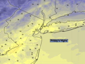
Fall is in the air this Friday. Wall to wall sunshine is expected with readings several degrees below the average high of the mid 60s. Strong high pressure is responsible for our bright, chilly conditions.
Tonight won’t be as cold as last night. No frost on the pumpkin this time.
As high pressure slips off the Northeast coast Saturday clouds will roll in from the South and East. Temperatures will be more seasonal.
A coastal storm will affect our area Sunday and Monday. The potential continues for rain, wind and coastal flooding to affect our region. Specifics on the details need to be ironed out. Areas of heavy rain and high winds are likely for many areas.
By Tuesday the storm will drift off the coast. Any morning showers will give way to some afternoon sun.
Stay tuned.
Keep it here for a no nonsense, no hype forecast.
Friday:
Sunny. Cool. Highs around 60º. Northeast to Southeast winds at 5mph.
Tonight:
Mostly clear. Lows in the lower to mid 50s in the City, the 40s inland. Southeast winds less than 5mph.
Saturday:
More clouds than sun. Highs in the mid 60s.
Sunday:
Periods of rain. Gusty winds. Highs in the lower 60s.
Monday:
Periods of rain. Gusty winds. Highs in the lower 60s.
Tuesday:
Morning shower, some afternoon sun. Highs in the upper 60s.