Synopsis:
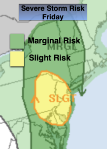
The storm named Debby is now a remnant low. A trough in the jet stream will pick Debbie up and move it up the spine of the Appalachians through Friday and be North of our area by late day. Humid conditions are expected Friday. There will be bands of showers and storms spiraling around the center. Anyone of these cells can contain torrential rain and possibly a severe storm. NJ is in a slight risk of severe thunderstorms Friday. There will be rapidly changing weather conditions. Winds will become gusty out of the South gusting to 30-50mph later in the day. When the remnants of Debbie has its closest approach to the area is when the steadiest and heaviest rain will fall. The timeframe looks to be around late afternoon or early evening Friday into the night.
The storm will be accelerating and should clear our region before sunrise on Saturday. Both weekend days will be mainly sunny and seasonable. There’ll be a gusty wind Saturday with lighter winds on Sunday.
Monday and Tuesday will be gems with abundant sunshine low humidity and warm readings as high pressure dominates.
Stay tuned.
Keep it here for a no nonsense, no hype forecast.
Tonight:
Scattered showers. Locally heavy rain. Becoming humid. Lows 70º throughout. East to Southeast winds at 5-10mph.
Friday:
Mostly cloudy. More humid. Scattered showers and storms. Locally heavy rain. Becoming windy. Highs around 80º. South winds at 15-25mph with gusts 30-50mph.
Saturday:
Mostly sunny and breezy. Highs in the mid 80s.
Sunday:
Mostly sunny. Highs in the lower 80s.
Monday:
Mostly sunny. Highs in the lower 80s.
Tuesday:
Mostly sunny. Highs in the mid 80s.