
Synopsis:
We have finally been rewarded with cooler temperatures, although we’ve paid the price. A cool Northeast to East flow around high pressure in Maine will be responsible for our unseasonably cool temperatures. Scattered showers are in the forecast through Thursday with a stationary front to our South. We are not looking at a deluge nor continuous rain. There will be dry times.
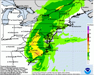
Now to Tropical Storm Debby. The storm will move back inland over South Carolina Thursday A trough in the jet stream will pick Debbie up and move it up the spine of the Appalachians through Friday. This Westward shift will result in the heaviest rain staying out of our region from this system. Good news. Scattered showers and humid conditions are expected Friday. When the remnants of Debbie has its closest approach to the area is when the steadiest and heaviest rain will fall. The timeframe looks to be around late afternoon or early evening Friday into the night. Gusty Southerly winds are possible at this time as well. The storm will be accelerating and should clear our region before sunrise on Saturday. Both weekend days will be mainly sunny and seasonable. There’ll be a gusty wind Saturday with lighter winds on Sunday.
Stay tuned.
Keep it here for a no nonsense, no hype forecast.
Tonight:
Scattered showers. Lows in the 60s throughout. Northeast winds at 5-10mph.
Thursday:
Cloudy and cool. Scattered showers. Highs in the lower to mid 70s.
Friday:
Mostly cloudy. More humid. Scattered showers. Becoming breezy. Highs around 80º.
Saturday:
Mostly sunny and breezy. Highs in the mid 80s.
Sunday:
Mostly sunny. Highs in the lower 80s.
Monday:
Mostly sunny. Highs in the lower 80s.