Synopsis:
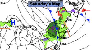
Low pressure in Southeastern Canada will be responsible for the gusty winds, cool temperatures and spotty showers Saturday. Sunday will be the better half of the weekend as a Southwesterly flow takes hold around high pressure off the Southeast coast.
Monday and Tuesday will feature a mix of sun and clouds as high pressure builds off the East coast. Above average readings will continue. The average high is in the lower 60s.
A warm front will approach on Wednesday. With it will be more clouds, cooler readings and a shower threat.
Stay tuned.
Keep it here for a no nonsense, no hype forecast.
Saturday:
Mostly cloudy. Spotty showers, windy and cooler. Highs in the mid 50s. West to Northwest winds at 15-25mph with gusts to 35mph.
Tonight:
Partly cloudy. Breezy. Lows in the mid 40s in the City, the 30s inland. West to Northwest winds at 15-25mph with gusts to 30mph, diminishing late.
Sunday:
Partly sunny. Milder. Highs near 70º.
Monday:
Mostly sunny. Warm. Highs around 70º.
Tuesday:
Partly sunny. Highs in the lower 70s.
Wednesday:
Mostly cloudy with scattered showers. Cooler. Highs in the lower 60s.