Synopsis:
Areas of rain are expected tonight. Local downpours are likely. A half inch to an inch of rain will fall by 5am Friday. It’ll be windy. This is all ahead of a cool front moving though the Ohio Valley and intensifying low pressure in the Eastern Great Lakes.
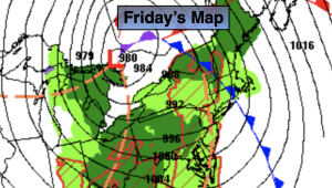
Friday will be a changeable day with scattered showers possible just about anytime. The majority of the day will be dry. Some sun may also shine. It’ll be breezy. Highs will be around five degrees above the average high of 60º.
Behind the low on Saturday skies will be partly cloudy. A spotty morning shower can’t be ruled out. It’ll be breezy and cooler. Sunday will be the better half of the weekend as a Southwesterly flow takes hold around high pressure off the Southeast coast.
Monday and Tuesday will feature a mix of sun and clouds as high pressure builds off the East coast. Above average readings will continue.
Stay tuned.
Keep it here for a no nonsense, no hype forecast.
Tonight:
On and off rain. Local downpours. Windy and mild. Lows in the 50s throughout. Southeast winds at 15-30mph with gusts to 40-50mph, especially at the coast.
Friday:
Morning showers, otherwise mostly cloudy with isolated afternoon showers. Windy. Highs in the mid 60s. South to West winds at 15-25mph with gusts to 35mph.
Saturday:
Mostly cloudy. Spotty morning showers. Breezy and cooler. Highs in the upper 50s.
Sunday:
Partly sunny. Milder. Highs in the mid to upper 60s.
Monday:
Mostly sunny. Warm. Highs around 70º.
Tuesday:
Partly sunny. Warm. Highs in the lower 70s.