Synopsis:
Unsettled is the weather word through much of the week. More rounds of rain are on the way. A couple areas of low pressure and their associated fronts will affect our region. The main storm will develop Wednesday on the coast and intensify as it moves North.
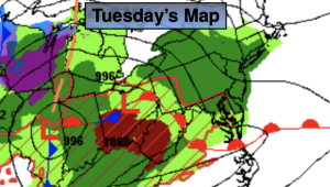
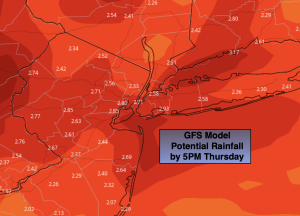
Round two of the rain will be with us today. This will be a result of a stationary front to our South with energy riding along it path. The rain may come down heavy for a time. On Wednesday low pressure will develop on the Mid-Atlantic coast and ride North. More rain is expected with this system. Temperatures will be well below average both days with a wind off the cold Atlantic.
By Thursday, the steady rain should be out of the area as intense low pressure moves into Eastern New England. The backside of the storm will draw colder air into the atmosphere so any rain showers have the possibility of going over to snow showers, especially inland.
Friday and Saturday the storm will well out to sea and weaken. We’ll be left with upper low pressure swinging through the region. This will cause the atmosphere to be unstable. A spotty shower is possible both afternoons under a mix of sun and clouds. A gusty Northwest breeze will create a nip in the air. We’ll definitely be experiencing Spring’s chilly side through the period.
Stay tuned.
Keep it here for a no nonsense, no hype forecast.
Tuesday:
Rain. Breezy. Raw. Highs in the upper 40s. East to Northeast winds increasing to 10-20mph.
Tonight:
On and off rain. Breezy. Lows in the lower to mid 40s throughout. East to Northeast winds at 10-20mph with gusts to 30mph at the coast.
Wednesday:
Rain. Highs in the mid 40s.
Thursday:
Mostly cloudy. Rain and snow showers (inland). Highs in the mid to upper 40s.
Friday:
Clouds and sun. Breezy. Spotty afternoon shower. Highs in the upper 40s.
Saturday:
Clouds and sun. Breezy. Spotty afternoon shower. Highs in the lower 50s.