Synopsis:
Unsettled will be the weather word for much of the upcoming week. A couple areas of low pressure and their associated fronts will affect our region. The lows will be developing and then organizing on the coast into one main storm later in the period. The first low will move South of the region today. This will result in a period of light rain this morning through early afternoon. The steadiest rain will be to the South with Northern areas receiving light amounts.
Tuesday and Wednesday will be wet with periods of rain as low pressure develops on the coast near our area. Temperatures will be well below average with a wind off the cold Atlantic.
By Thursday, the steady rain should be out of the area as intense low pressure moves into Eastern New England. The backside of the storm will draw colder air into the atmosphere so any rain showers have the possibility of going over to snow showers, especially inland.
We’ll finally get to dry out on Friday. A gusty Northwest breeze along with a mix of sun and clouds is expected. There will be a nip in the air. We’ll definitely be experiencing Spring’s chill this week.
Stay tuned.
Keep it here for a no nonsense, no hype forecast.
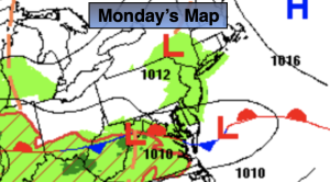
Monday:
A period of light rain. Cooler. Highs in the upper 40s to lower 50s. Northeast winds at 5mph.
Tonight:
Mostly cloudy. Lows in the lower to mid 40s throughout. Light and variable winds.
Tuesday:
Rain. Breezy. Raw. Highs in the mid to upper 40s.
Wednesday:
Rain. Highs in the mid 40s.
Thursday:
Rain and snow showers. Highs in the mid to upper 40s.
Friday:
Clouds and sun. Highs in the upper 40s.