Synopsis:
The Easter weekend will start off with sun giving way to clouds today. A weak disturbance will ride rapidly from West to East later this afternoon and night. Scattered areas of light rain or showers are possible after 4pm Saturday. The areas of light rain will quit shortly after midnight. It’s looking like there’ll be dry Easter Bonnets on Sunday. A mild day with abundant sunshine is expected. Both weekend days will be mild.
Unsettled will be the weather word for much of the upcoming week. A couple areas of low pressure and their associated fronts will affect our region. The lows will be developing and then organizing off the coast into one main storm later in the period. A few inches of rain quite possible by Thursday.
Stay tuned.
Keep it here for a no nonsense, no hype forecast.
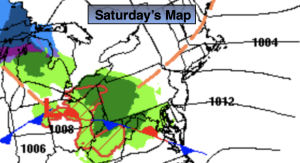
Saturday:
Sun to clouds. Late day scattered showers. Highs in the upper 50s. West winds at 10-15mph.
Tonight:
Areas of light rain early. Clearing skies late. Lows around 40º in the City, the 30s elsewhere. West winds at 5mph.
Easter Sunday:
Mostly sunny. Mild. Highs in the lower to mid 60s.
Monday:
Rain. Cooler. Highs in the upper 40s.
Tuesday:
Rain. Highs in mid to upper 40s.
Wednesday:
On and off rain. Highs in mid to upper 40s.