Synopsis:
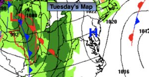
An offshore storm will retrograde some today. This will cause clouds to roll in from the ocean. Readings will be several degrees cooler than Monday with the cloud cover. You’ll notice the chill.
Areas of drizzle and fog will develop tonight with an approaching front from the West and the onshore flow. This will continue into Wednesday.
On Thursday a low will develop off the Carolina’s. The rain shield from this storm has the potential to graze the region. The best chance for seeing a steadier/heavier rain at this time is coastal areas. Farther inland the rain maybe lighter.
Behind the departing low on Friday skies will be partly sunny. Temperatures will be near average.
The Easter weekend will start off with abundant sunshine on Saturday. Sunday looks to be bright with dry Easter Bonnets! Both days will be mild.
Stay tuned.
Keep it here for a no nonsense, no hype forecast.
Tuesday:
Mostly cloudy. Cooler. Highs in the mid to upper 40s. Northeast winds at 8-12mph.
Tonight:
Cloudy with areas of drizzle and fog. Lows in the 30s to around 40º throughout. Northeast winds at 5mph.
Wednesday:
Mostly cloudy. Spotty shower possible. Areas of fog. Highs in the mid 50s.
Thursday:
Chance of rain. Highs in the lower to mid 50s.
Friday:
Partly sunny. Highs in the mid 50s.
Saturday:
Sunny. Highs in the mid to upper 50s.