Synopsis:
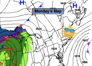
It’ll be a fine start to the workweek with strong high pressure funneling in from Eastern Canada. The sun will dominate with near seasonable readings (the lower 50s).
An offshore storm will retrograde some on Tuesday. This will cause clouds to roll in from the ocean. Readings will be a few degrees cooler than Monday with the cloud cover.
Spotty showers are possible Wednesday as a weakening front moves through.
On Thursday a low will develop off the Carolina’s. The rain shield from this storm has the potential to graze the region.
Behind the departing low on Friday skies will be partly sunny. Temperatures will be near average.
Stay tuned.
Keep it here for a no nonsense, no hype forecast.
Monday:
Sunny. Seasonable. Highs in the lower 50s. Northeast winds at 10-20mph.
Tonight:
Mostly clear. Lows in the upper 30s in the City, around 30º inland. Northeast winds at 8-12mph.
Tuesday:
Mostly cloudy. Cooler. Highs in the mid to upper 40s.
Wednesday:
Mostly cloudy. Spotty shower possible. Highs in the mid 50s.
Thursday:
Chance of rain. Highs in the lower to mid 50s.
Friday:
Partly sunny. Highs in the mid 50s.