Synopsis:
A Northwesterly flow will prevail this week as the jet stream will be moving in from West to East. This setup will prevent any storm development or extremes in temperature through Friday.
Spring arrives today at 11:06pm. It’ll be a cool greeting as cooler air from Canada moves into the region under a mix of sun and clouds. Wednesday will be more seasonable ahead of the next cold front. A spotty shower is possible during the afternoon. Then readings will become chilly once again for the end of the week under abundant sunshine.
Saturday’s will feature a storm on the map to our South . The computer models have brought the storm closer to the region. The potential for rain and wind has increased for the area.
Stay tuned.
Keep it here for a no nonsense, no hype forecast..
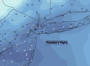
Tuesday:
Partly sunny. Cooler. Highs in the mid to upper 40s. West to Northwest winds at 10-20mph.
Tonight:
Partly cloudy. Lows in the upper 30s in the City, near freezing inland. Southwest winds at 5mph.
Wednesday:
Partly sunny. Breezy. Spotty afternoon shower possible. Highs in the lower to mid 50s.
Thursday:
Mostly sunny. Cooler. Highs in the lower to mid 40s.
Friday:
Partly sunny. Highs in the mid 40s.
Saturday:
Chance of rain. Becoming windy. Highs in the lower 50s.