Synopsis:
Unsettled is the weather word for much of the next 5 days. One low has moved thorough the area with two more systems in queue for through the weekend.
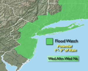
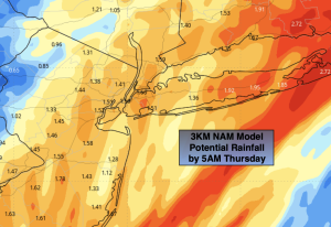
The morning commute will be dry, but don’t be fooled the potential of heavy rain is there for the PM commute. A second low will be responsible for our wet conditions. The will low move up our coastline this evening and night with heavy rain. A Flood Watch has been posted for a good chunk of the area. The ground is saturated from Tuesday’s rain. An additional one to three inches of rain will cause flooding of streets, low lying areas, creeks and streams. Never drive through a flooded roadway- TURN AROUND-DON’T DROWN. You can’t judge how deep that water is. The jackpot area looks to be Long Island for the heaviest rainfall.
The low will move rapidly out of our area before sunrise on Thursday. The day now looks to be rain-free with clouds dominating. If we’re lucky we’ll get to see a bit of sun.
Friday will be the best day of the next five. Abundant sunshine is anticipated as strong high pressure noses in from Eastern Canada.
Low pressure number three will move into the East on Saturday night and Sunday morning with more rain. Duck weather for sure. So we get three lows in 5 days and not an ounce of cold air for snow. Another Carolina like Winter.
Stay tuned.
Keep it here for a no nonsense, no hype forecast..
Wednesday:
Cloudy. Rain by afternoon, becoming heavy at times. Highs in the lower 50s. Southeast to Northeast winds at 5-10mph.
Tonight:
Heavy rain. Rain will taper off with a few hours either side of midnight. Lows in the 40s throughout. Northeast to North winds at 5-10mph.
Thursday:
Mostly cloudy. Highs in the lower 50s.
Friday:
Mostly sunny. Highs in the lower 50s.
Saturday:
Mostly cloudy. Rain likely by dark. Highs in the upper 40s.
Sunday:
Morning rain, some afternoon sun. Highs in the lower 50s.