Synopsis:
Today will be the better half of the weekend as high pressure builds in our area. It’ll feel like Spring with readings soaring into the 60s!
The clouds will win the battle on Monday as a marine influence takes hold of our region. Temperatures will remain well above the average highs of the mid 40s.
Unsettled is the word for midweek. Two low pressure systems will move up from the South. One on Tuesday the other on Thursday. There will be a brief break on Wednesday but showers will roll in later in the day. It will still be mild as all of the cold air is bottled up in Canada.
Stay tuned.
Keep it here for a no nonsense, no hype forecast..
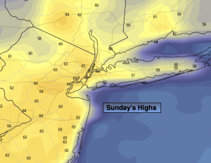
Sunday:
Partly sunny. Mild. Highs in the lower 60s. Northwest winds at 5-10mph.
Tonight:
Mostly cloudy. Another mild night. Lows in the 40s throughout. Northwest to East winds at 5mph.
Monday:
Clouds, some sun. Highs in the mid 50s. Much cooler at the coast.
Tuesday:
Chance of rain. Highs around 50º.
Wednesday:
Mostly cloudy. Showers possible later in the day. Highs in the mid 50s.
Thursday:
Rain likely. Highs in the upper 40s.