Synopsis
High pressure will slip off the coast on Friday resulting in a Southerly flow. This will bring readings to at least ten degrees above the average high of the lower 40s. Clouds will give way to mostly sunny skies.
The Spring feel will continue into the weekend. A washed out front will work through on Saturday. A few showers are possible in the afternoon. Super Bowl Sunday will be dry and mild.
Clouds will roll in on Monday ahead of a developing system over the central Appalachians. This low will redevelop East of Delaware on Tuesday and then move up and off the coast. Rain will develop Monday night or Tuesday morning. The rain has the potential to go over to snow inland on Tuesday with a potential accumulation. A lack of Arctic air will most likely keep the coast mainly rain, possibly ending as some snow. The event is over three days away. Much can change.
Stay tuned.
Keep it here for a no nonsense, no hype forecast.
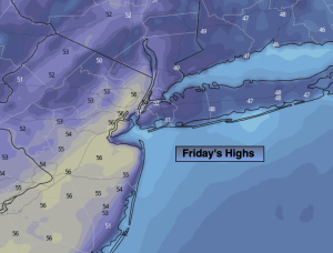
Friday:
Clouds to sun. Mild. Highs in the lower 50s. South to Southeast winds 5-10mph.
Tonight:
Partly cloudy. Lows in the mid 40s in the City, the 30s inland. Light South winds.
Saturday:
Mostly cloudy. Threat of afternoon showers. Very mild. Highs in the mid to upper 50s.
Sunday:
Partly sunny. Mild. Highs in the lower 50s.
Monday:
Increasing clouds. Highs in the mid 40s.
Tuesday:
Rain and or snow depending on location. Highs around 40º.