Synopsis
We’ll go above average with the mercury today as the lack of Arctic air continues as we turn the page to February. We will finally get to witness a bit of sun today, but the clouds should once again win the battle. We’ll take what we can get.
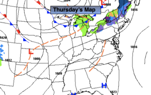
Showers will develop toward midnight as a cool front approaches tonight.
On Friday, Groundhog Day, the front will move off the coast in the morning. A shower is possible, otherwise skies will be partly sunny with readings still above the average highs of the upper 30s.
Tolerable conditions are expected for the weekend as high pressure noses in from Eastern Canada. Abundant sunshine and above average temperatures are anticipated. Monday’s forecast will be no different.
There are no storms in sight. A dismal outlook for snow lovers.
Stay tuned.
Keep it here for a no nonsense, no hype forecast.
Thursday:
More clouds than sun. Mild. Highs in the mid to upper 40s. West to Southwest winds at 5-10mph.
Tonight:
Showers developing toward midnight. Lows in the upper 30s in the City, the lower to mid 30s inland. West to Southwest winds at 5mph.
Friday:
Clouds and sun. Spot AM shower. Highs in the mid 40s.
Saturday:
Sunny. Highs in the lower to mid 40s.
Sunday:
Sunny. Highs in the mid 40s.
Monday:
Sunny. Highs around 40º.