Synopsis:
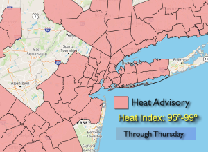
Today will feel every bit like July as temperatures soar and humidity levels remains high. This is all courtesy of a bubble of hot air over the region and an upper level high anchored over the East. Summer doesn’t want to let go! A Heat Advisory continues for many areas. High temperatures and high humidity will make it feel like the mid to upper 90s. Some record high temperatures are possible. If the temperature hits 94º in the City it will be the hottest day this Summer. That’s quite unusual for that to possibly occur six days into September.
The heat will break as high pressure weakens and moves offshore by Friday. At this time a front will approach from the West. The threat of late day and evening storms are in the forecast although the latest guidance has it mainly dry. More numerous showers and storms are likely on Saturday and Sunday as the front stalls over the region.
Stay tuned.
Keep it here for a no nonsense, no hype forecast.
Wednesday:
Mostly sunny. Hot. Highs in the mid 90s. Cooler at the coast. Northwest winds at 5mph.
Tonight:
Mostly clear and warm. Lows in the mid 70s in the City, the 60s inland. Light Southwest winds.
Thursday:
Partly sunny. Hot. Highs around 90º.
Friday:
Partly sunny. Not as hot. Late day or evening shower or storm possible. Highs in the mid 80s.
Saturday:
Mostly cloudy. Scattered showers and storms possible. Highs in the lower 80s.
Sunday:
Mostly cloudy. Scattered showers. Highs around 80º.