Synopsis:
Low pressure to our North will result in a dry West wind today. This will result in a midweek delight. Sunny skies, very warm conditions with low humidity is expected. Highs will be just above the average highs of the mid 80s.
A disturbance will approach the area from the West on Thursday. Sunshine will give way to the threat of afternoon showers and storms.
Friday and the weekend look like fine mid-August days with abundant sunshine and warm temperatures. Weak high pressure will be responsible for our smiles!
Stay tuned.
Keep it here for a no nonsense, no hype forecast.
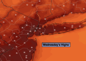
Wednesday:
Sunny, warm and much less humid. Highs in the mid to upper 80s. West to Northwest winds at 8-12mph.
Tonight:
Mostly clear. Lows around 70º along the urban corridor, the 60s inland. West to Southwest winds at 5mph.
Thursday:
Morning sun will give way to the threat of afternoon showers and storms. Highs in the upper 70s.
Friday:
Sunny. Highs in the mid 80s.
Saturday:
Mostly sunny. Highs in the mid 80s.
Sunday:
Partly sunny. Highs in the mid to upper 80s.