Synopsis:
A weak cool front will work through the region today. Morning clouds will give way to a mix of sun and clouds. It’ll become breezy and less humid during the afternoon. Since the system is moisture starved I’ve kept the threat of any storms out of the forecast.
Low pressure to our North will result in a dry West wind. This will result in a midweek delight. Sunny skies and much lesss humid conditions are expected. It will be quite warm.
A disturbance will approach the area from the West on Thursday. Sunshine will give way to the threat of afternoon showers and storms.
Friday and Saturday look like winners with abundant sunshine and seasonable temperatures. Weak high pressure will be responsible for our smiles!
Stay tuned.
Keep it here for a no nonsense, no hype forecast.
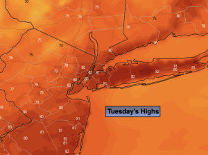
Tuesday:
Morning cloud will give way to a mix of sun and clouds. It’ll be warm and breezy. Humidity levels will come down during the afternoon. Highs in the lower to mid 80s. West winds increasing to 10-20mp with gusts to 25mph.
Tonight:
Clear and comfortable. Lows in the mid to upper 60s along the urban corridor, the upper 50s to lower 60s inland. West winds at 8-12mph.
Wednesday:
Mostly sunny, warm and much less humid. Highs in the mid to upper 80s.
Thursday:
Morning sun will give way to the threat of afternoon showers and storms. Highs in the mid 80s.
Friday:
Mostly sunny. Highs in the mid 80s.
Saturday:
Mostly sunny. Highs in the mid 80s.