Synopsis:
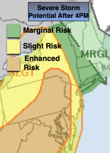
A warm front over the region today will cause two rounds of wet weather. The first round was this morning with showers and locally heavy rain. There will be a break with hazy sun later this morning and afternoon. The second round will be later today and this evening. The graphic above depicts much of the area in a slight to enhanced areas of severe storms. Keep and eye to the sky for threatening weather after 4pm today. The threat of showers and storms will continue into the evening.
A cool front will work through the region Tuesday. A mix of sun and clouds is expected with the threat of an isolated storm. The majority of the day will be dry.
The low will push well North of our area on Wednesday leaving us with a midweek delight. Sunny skies and less humid conditions are expected. This fab weather will continue for Thursday. A few more clouds are expected for Friday. At this time JMW is keeping it dry.
Stay tuned.
Keep it here for a no nonsense, no hype forecast.
Monday:
Morning showers giving way to hazy skies. Humid. Chance of showers and storms during the evening and night. Highs in the upper 70s to lower 80s.
Tonight:
Showers and thunderstorms likely this evening. Lows in the 60s to around 70º in the City. Southeast to Southwest winds at 5-10mph.
Tuesday:
Hazy, warm and becoming less humid. Spotty afternoon storm. Highs in the mid 80s.
Wednesday:
Mostly sunny, warm and much less humid. Highs in the mid 80s.
Thursday:
Partly sunny. Highs in the mid 80s.
Friday:
Clouds and sun. Highs in the mid 80s.