Synopsis:
Above average temperatures will continue through Friday as a Southerly flow continues around offshore high pressure. A mix of clouds and sun is expected for today with readings at least five degrees above the average high of the lower 50s. A warm front will approach from the South on Thursday with the chance of a few showers-it’ll be unseasonably warm.
The threat of showers is in the forecast for Friday morning for areas to the South of the City as cool front may get hung up over the region. The sun will most likely return during the day.
On Saturday Low pressure will develop over the Ohio Valley with a secondary low most likely develop near our region. Showers are likely with readings below the average high of 51º.
Sunday will be the brighter half of the weekend as high pressure dries the Northeast out. It’ll be mild as well.
Stay tuned.
Keep it here for a no nonsense, no hype forecast.
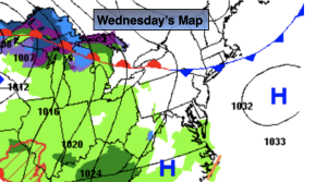
Wednesday:
Clouds and sun. Mild. Highs around 60º. Cooler over Long Island and coastal areas. South winds at 5-10mph.
Tonight:
Mostly cloudy. A few showers possible late. Lows in the 40s to around 50º in the City. South winds less than 5mph.
Thursday:
Clouds and sun. Warm. Spotty showers possible. Highs in the mid 60s.
Friday:
Clouds and sun.Spotty showers possible mainly in the morning and to the South. Most areas likely remaining dry. Highs in the mid 50s.
Saturday:
Cloudy with scattered showers. Cooler. Highs in the mid 40s.
Sunday:
Sunny. Mild. Highs in the mid 50s.