Synopsis
The weekend will not feel like it supposed to be the coldest time of the year-something we’re quite used to. Conditions will remain tranquil with once again very mild temperatures returning as a Southwest wind takes hold around departing high pressure. Today will feature partly sunny skies. More clouds are expected for Sunday as a weakening front approaches.
No major changes are expected for Monday.
A colder airmass will work in for the last day of January and into February’s debut on Wednesday. At this time no precipitation is likely.
Stay tuned.
Keep it here for a no hype, no nonsense forecast
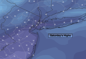
Saturday:
Sun & Clouds. Milder. Highs in the upper 40s to around 50º. Southwest to West winds at 5-10mph.
Tonight:
Partly cloudy. Lows in the upper 30s along the urban corridor, the 20s & 30s inland. Southwest to Southeast winds 5mph.
Sunday:
Mostly cloudy. An isolated shower is possible late. Mild. Highs around 50º.
Monday:
Clouds to sun. Highs in the mid 40s.
Tuesday:
Partly sunny. More seasonable. Highs in the upper 30s.
Wednesday:
Partly sunny. Colder. Highs in the lower to mid 30s.