Synopsis:
High pressure will move overhead today resulting in a bright but cool day. Winds will not be an issue.
A cold front will approach on Wednesday. Rain is likely by morning with increasing winds. It’ll be mild ahead of the approaching system on this last day of November.
December’s debut on Thursday will be more typical of the season with colder readings and a gusty wind as a Canadian airmass moves in. Sunny, chilly conditions will continue for Friday. Both days will feature readings a few degrees below average high of 49º.
A mix of sun and clouds is expected for Saturday. A few showers are possible as a cool front approaches. It’ll be a mild day.
Stay tuned.
Keep it here for a no hype, no nonsense forecast.
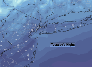
Tuesday:
Mostly sunny. Cool. Highs in the mid 40s. North to Southeast winds at 5mph.
Tonight:
Increasing clouds. Lows in the mid 40s along the urban corridor, the 30s inland. Southeast winds at 5mph.
Wednesday:
Rain developing by mid morning. Becoming windy. Mild. Highs in the mid to upper 50s.
Thursday:
Mostly sunny, windy and colder. Highs in the mid 40s.
Friday:
Sunny and chilly. Highs in the mid 40s.
Saturday:
Mostly cloudy with a few showers possible. Mild. Highs in the mid 50s.