Synopsis:
Low pressure over the Canadian maritimes and strengthening high pressure over the Central Appalachians will result in a breezy but mainly sunny day. Highs will be just above the average of 50º.
High pressure will move overhead on Tuesday resulting in a bright but cool day.
A cold front will approach on Wednesday. Rain is likely by midday with increasing winds. It’ll be warm ahead of the approaching system on this last day of November.
December’s debut on Thursday will be more typical of the season with colder readings and a gusty wind as a Canadian airmass moves in. Sunny, chilly conditions will continue for Friday. Both days will feature readings a few degrees below average.
Stay tuned.
Keep it here for a no hype, no nonsense forecast.
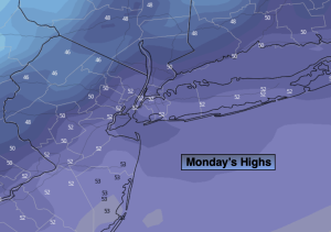
Monday:
Mostly sunny. Breezy. Highs in the lower 50s in the City, the upper 40s inland. Northwest winds at 10-20mph with gusts to 25mph.
Tonight:
Clear. Much colder than recents nights. Lows in the mid 30s along the urban corridor, the 20s inland. Northwest winds diminishing to 5mph.
Tuesday:
Sunny. Seasonable. Highs in the upper 40s.
Wednesday:
Rain developing toward midday. Becoming windy and warm. Highs in the upper 50s.
Thursday:
Partly sunny, windy and colder. Highs in the mid 40s.
Friday:
Sunny and chilly. Highs in the mid 40s.