Synopsis:
Our unusual warm November continues. And it will only get warmer the next few days.
High pressure will move off the Northeast coast through this weekend. Temperatures will be well above the average highs of the upper 50s. The forecast through Monday will be a familiar one with warm readings as high pressure dominates. There maybe more clouds and fog both days this weekend but the sun will eventually shine.
Monday will be the last unseasonably warm day as a cold front approaches. Highs will get well into the 70s. The front will come through will little fan fare (dry).
Indian Summer is here for those areas that received a frost or freeze (which is most locations outside the urban corridor). Enjoy!
A Canadian airmass will move in for Tuesday bringing our temperatures more closer to average. The sun will continue to dominate.
Stay tuned.
Keep it here for a no hype, no nonsense forecast.
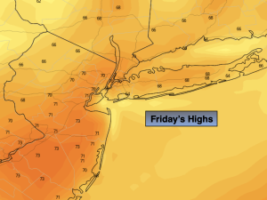
Friday:
Mostly sunny. Highs in the upper 60s to around 70º. Southeast winds at 5-10mph.
Tonight:
Mostly cloudy with patchy fog. Lows around 60º in the City, the 50s inland. These readings are warmer than the average high for the day! South winds less than 5mph.
Saturday:
Morning clouds and patchy fog. Becoming partly sunny. Warm. Highs in the lower to mid 70s.
Sunday:
Morning clouds. Becoming partly sunny. Warm. Highs in the mid 70s.
Monday:
Partly sunny. Warm. Highs in the mid 70s.
Tuesday:
Sunny. Cooler. Highs in the lower 60s.