Synopsis:
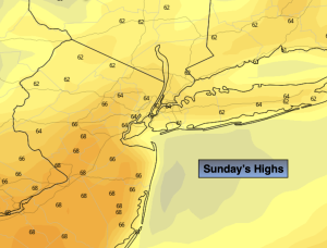
Our weekend Fall spectacular will continue. Sunday will feature high pressure moving off the Southeast coast. A mix of sun and clouds is expected with seasonable readings (the average high for the date is 65º).
Clouds will increase tonight. Scattered showers are possible late as the next weather systems works our way.
More clouds are anticipated for Monday as low pressure develops over the Northeast and a cold front front approaches from the West. Scattered showers are possible, especially in the morning.
Tuesday through Thursday will be Crisp despite plenty of sunshine . Temperatures will be well below average as our first shot of unseasonably cool Canadian air moves in. Readings will be close to ten degrees below average.
Keep it here for a no hype, no nonsense forecast.
Sunday:
Sun and clouds. Highs in the mid 60s. Northwest to West winds at 5mph.
Tonight:
Increasing clouds. Showers possible late. Lows in the mid 50s in the City, the 40s elsewhere. West to Southeast winds at 5mph.
Monday:
Mostly cloudy with scattered showers, mainly in the morning. Highs in the mid 60s.
Tuesday:
Mostly sunny, breezy and cooler. Highs in the mid 50s.
Wednesday:
Partly sunny. Highs in the mid 50s.
Thursday:
Mostly sunny. Highs in the mid 50s.