Synopsis:
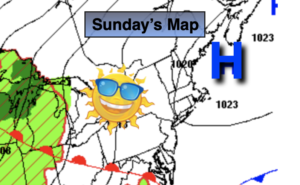
The last weekend of August will be a winner as high pressure from the North dominates. Sunday will feature a mix of sun and clouds. A stray shower can’t be ruled out but the majority of the day will be just fine. Temperatures will be more seasonable in the lower to mid 80s.
It looks like a bright, warm stretch as we close out August and welcome September on Thursday. High pressure will be in control. The only threat of a storm is Tuesday night with a weak front passing through.
Keep it here for a no hype, no nonsense forecast.
Sunday:
Sun and clouds. Highs in the lower to mid 80s. East to Southeast winds at 5-10mph.
Tonight:
Partly cloudy. Lows around 70º in urban areas, the 60s North and West. Southeast winds at 5mph.
Monday:
Mostly sunny. Humid. Highs in the mid 80s.
Tuesday:
Mostly sunny, hot and humid. Highs in the upper 80s to lower 90s.
Wednesday:
Mostly sunny. Not as humid. Highs in the mid to upper 80s.
Thursday:
Mostly sunny. Highs in the mid to upper 80s.
Catch me Saturday on the Fox Business Network from 6am-9am on the Weather Stream until 10am. Find us on Tubi, Roku TV and YouTube TV and as always the Fox Weather App. It’s Free!