Synopsis:
Relief from the heat has finally arrived! It will not be as hot or humid as the last several days as an airmass pushes in from the North. Temperatures will be at least ten degrees lower than Tuesday and the humidity will be much lower as well under a mix of clouds and sun.
A weak low may develop off the coast Thursday morning resulting in the possibility of scattered showers, especially for Eastern areas. Skies should become mainly sunny by afternoon. Seasonable readings are expected.
Spectacular weather is expected Friday into the weekend as high pressure moves in from the Northwest. Abundant sunshine, pleasantly warm readings and low humidity is expected. We have been rewarded!
Stay tuned.
Keep it here for a no hype, no nonsense forecast.
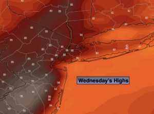
Wednesday:
Clouds and sun. Cooler than recent days with low humidity. Highs in the mid 80s. North to Southeast winds at 5-10mph.
Tonight:
Partly cloudy, showers possible late. Lows around 70º in urban areas, the 60s North and West. Light Southeat to Northeast wind.
Thursday:
Morning showers possible. A mix of clouds and sun. Seasonable. Highs in the lower to mid 80s.
Friday:
Mostly sunny and comfortable. Highs in the lower 80s.
Saturday:
Sunny. Highs in the lower to mid 80s.
Sunday:
Sunny. Top ten day. Highs in the mid 80s.
Catch me on the Fox Weather Stream from 10am-1pm Wednesday. Find us on Tubi, Roku TV and YouTube TV and as always the Fox Weather App. It’s Free!