Synopsis:
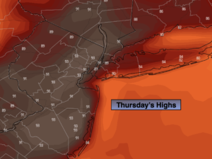
Today the humidity will increase as a push of tropical air comes up from the South. Early morning scattered storms are possible, especially East of the City, otherwise a mix of sun and clouds is expected. Readings will approach 90º. A late day or evening isolated storm is possible as the atmosphere becomes quite unstable.
It’ll be a warm and muggy night partly cloudy skies.
Friday will be warm and moderately humid under a bright sky. A weak cool front will move through at night with the threat of scattered showers and storms.
The last weekend of July will be a winner as high pressure works in from the Great Lakes. It’ll be bright, warm but less humid.
August’s debut on Monday will be no different with warm and bright conditions as weak high pressure moves overhead.
Stay tuned.
Keep it here for a no hype, no nonsense forecast.
Thursday:
Clouds and sun. Hot and humid. Scattered early morning showers or storms possible, especially East. Highs around 90º. A late day or evening isolated storm is possible. Southwest winds at 8-15mph.
Tonight:
Partly cloudy. Lows in the mid 70s in urban areas, the upper 60s to around 70º. West winds at 5mph.
Friday:
Sun and clouds. Warm. Highs in the upper 80s.
Saturday:
Mostly sunny, warm and less humid. Highs in the mid to upper 80s.
Sunday:
Sunny. Highs in the mid to upper 80s.
Monday:
Sunny. Highs in the mid to upper 80s.
Catch me on the Fox Weather Stream from 10am to 1pm Thursday. Find us on Tubi, Roku TV and YouTube TV and as always the Fox Weather App. It’s Free!