Synopsis:
The heatwave will continue through Monday. Much of the Southern two thirds of the nation is sweltering as hot high pressure stretches from the Plains to the Atlantic coast. The hottest temperatures of the season so far are expected here on Sunday as the heat wave peaks. Monday should be the last day of this torture as a cool front, hopefully with some meaning, works in. Scattered storms are possible in the afternoon.
Relief from the heat will arrive on Tuesday behind the cool front. Listen, it won’t be 70º but anything is better than 100º. It’ll be a similar forecast for Wednesday.
By Thursday the humidity will increase as a push of tropical air comes up from the South.
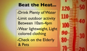
During the heat wave please take it slow outdoors. Drink plenty of fluids. Check on the elderly and pets. Listen to your body, if you feel dizzy or fatigue take a break and try to stay in air-conditioned or cooler areas.
Stay tuned.
Keep it here for a no hype, no nonsense forecast.
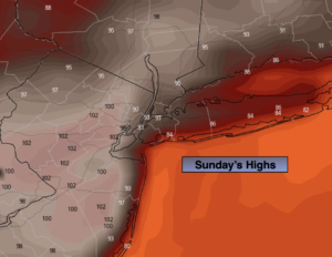
Sunday:
Sunny. Oppressive. Breezy. Highs 95º-102º. Heat index in many areas will be at or over 105º. Cooler along the immediate coast and parts of Long Island and coastal Connecticut. Southwest winds at 10-20mph.
Tonight:
Partly cloudy. Very warm. Lows in the upper 70s to lower 80s in urban areas, the 70s North and West. Southwest winds at 8-12mph.
Monday:
Sun and clouds. Hot and humid. Scattered afternoon storms. Highs in the lower 90s.
Tuesday:
Mostly sunny. Not as hot or humid. Highs in the upper 80s.
Wednesday:
Mostly sunny. Very warm. Highs in the upper 80s.
Thursday:
Clouds and sun. Very warm. More Humid. Scattered showers or storms possible. Highs in the upper 80s.
Catch me on the Fox Business Network from 6am to 9am Sunday and the Fox Weather Stream until 10am. Find us on Tubi, Roku TV and YouTube TV and as always the Fox Weather App. It’s Free!