Synopsis:
High pressure that gave the region bright, warm conditions with low humidity will shift offshore through the end of the week. This will result in a rise in temperatures under a bright sky today. It’ll become hot and humid as we greet the new month on Friday.
The 4th of July weekend will start off steamy. An approaching cool front will spark showers and storms on Saturday.
Relief will arrive on Sunday as the front pushes offshore. Morning showers are possible but the sun should return during the day.
The 4th of July forecast will make most smile. Sunny skies, warm temperatures and low humidity is expected!
Stay tuned.
Keep it here for a no hype, no nonsense forecast.
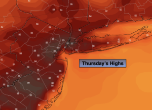
Thursday:
Sunny. Warmer. Highs in the upper 80s. Northwest to Southwest at 5-10mph.
Tonight:
Clear. Lows in the lower 70s in the City, the 60s inland. Southwest at 5mph.
Friday:
Sunny, hot and humid. Highs in the lower 90s.
Saturday:
Hazy, warm and humid. Chance of showers and storms. Highs in the mid 80s.
Sunday:
Morning showers possible. Afternoon sun. Not as hot or humid. Highs in the mid 80s.
4th of July:
Sunny and warm. Highs in the mid 80s.
Catch me on the Fox Weather Stream from 10am to 1pm Thursday. Find us on Tubi, Roku TV and YouTube TV and as always the Fox Weather App. It’s Free!