Synopsis:
The first weekend of Summer will be a memorable one. Abundant sunshine and very warm to hot readings are expected as high pressure moves over the region and into the Atlantic. Humidity will be a notch higher on Sunday. Please slather on the sunscreen as the UV index will be a very high 9 on a scale of 1 to 12.
Scattered showers are likely Monday with a the passage of a cool front.
Tuesday and Wednesday will be beauties with near average readings and low humidity as high pressure moves in from the Great Lakes.
As the high shifts offshore a Southwesterly wind will take hold on Thursday. This will result in a rise in temperatures under a bright sky.
Stay tuned.
Keep it here for a no hype, no nonsense forecast.
Tonight:
Clear. Lows in the lower 70s in the City, the 60s inland. South to Southwest winds less than 5mph.
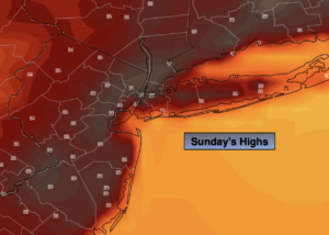
Sunday:
Sunny, hot and more humid. Highs around 90º. Cooler at the coast. Southwest to South winds at 10-15mph with gusts to 25mph during the afternoon.
Monday:
Mostly cloudy with scattered showers. Humid. Highs around 80º.
Tuesday:
Sunny. Less humid. Highs around 80º.
Wednesday:
Sunny. Highs around 80º.
Thursday:
Mostly sunny. Warmer. Highs in the mid to upper 80s.
Catch me on the Fox Business Network from 6am-9am this weekend and on the Weather Stream until 10am. Find us on Tubi, Roku TV and YouTube TV and as always the Fox Weather App. It’s Free!